


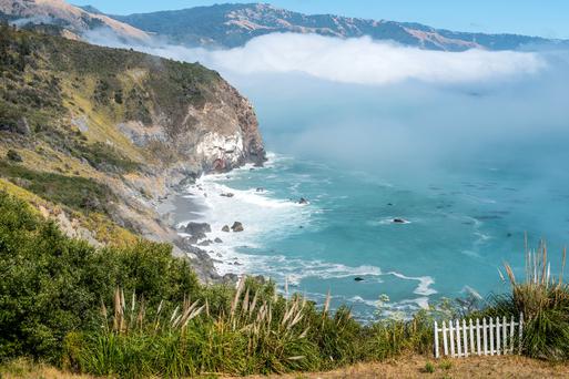

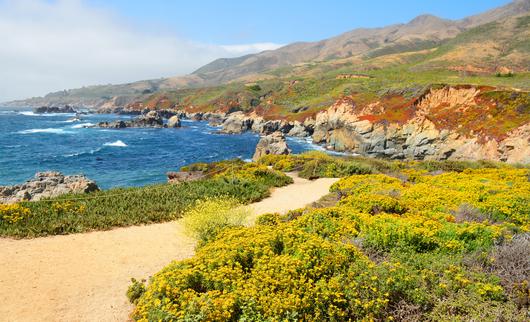
Your Guide to Visiting Garrapata State Park
Check out this beautiful Central Coast park with our guide to visiting Garrapata State Park.

Put on your sturdy shoes and head to the gorgeous hiking trails in Sacramento for a day of rustic bliss. Check out these trails to hike now.
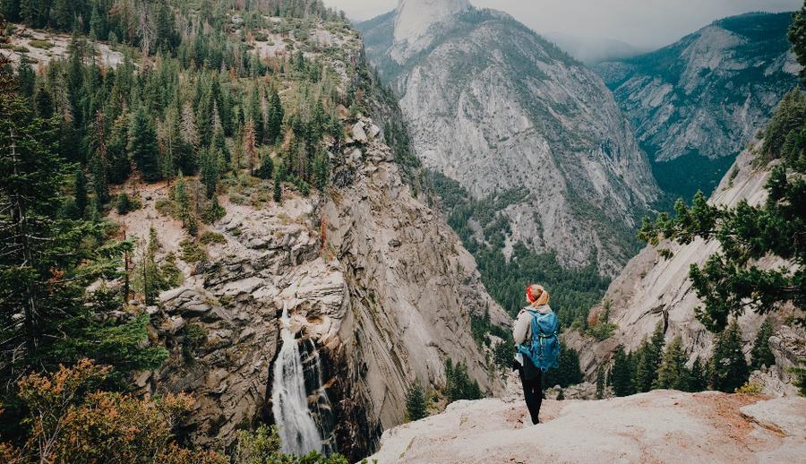
Soothing winds, mellow rivers, and trails drenched in rugged perfection—Sacramento’s your ultimate getaway. The region boasts everything from dense woods to dizzying peaks, inviting day-hikers on a journey of exploration. Whether you’re a nature lover or simply looking for free things to do in Sacramento, prepare to fall in love with each footfall. Put on your sturdy shoes and head to the gorgeous hiking trails in Sacramento for a day of rustic bliss.

Location: 1315 10th Street, Sacramento
Level of Difficulty: Easy
Distance: 1.1 miles
Route: Loop
Dogs allowed: On leash
Blooming cacti, cascading fountains, and historic memorials await you at the Capitol Building—one of Sacramento’s most popular hiking trails. Paved along with asphalt and bricks, the smooth trail surface makes for an experience ever-so-serene. Shaded areas dot the beautiful Capitol Park, making for a great picnic spot with your four-legged friend.
Location: American River Parkway, Sacramento
Level of Difficulty: Easy
Distance: 28 miles
Route: Point to Point
Dogs allowed: On leash
Winding along the American River, the Jedediah Smith Trail starts at Discovery Park in downtown Sacramento. Entrances range from main roads to railways and lake parks—each one more scenic than the other. For the most part, the charming pathways are easy to navigate, with the exception of a few downriver spur trails.
As you’re trekking through the smooth, paved surfaces, take a minute to appreciate the scenery around you. The American River is your primary water sport destination. Whether you’re keen on kayaking or whitewater rafting, the perfect spot awaits you around the best hiking trail in Sacramento.
Location: West Sacramento
Level of Difficulty: Easy
Distance: 9.5 miles
Route: Out and back
Dogs allowed: On leash
Nested on the eastern bank of the Sacramento River, this scenic trail encompasses two disconnected stretches. Meander through the streets of Old Sacramento all the way to the railroad tracks. Panoramic views are guaranteed at Tiscornia Park— the outset for your adventure. Head south and pass the Sacramento River Water Intake Structure, where a quaint fountain will cool you off.
Location: Auburn State Recreation Area, Auburn
Level of Difficulty: Easy
Distance: 2.2 miles
Route: Out and back
Dogs allowed: Yes
Trekking the Western States trail is like taking a walk through history. The Sierra Nevada Mountains— traveled first by the Indigenous peoples of the region—boast peaks so magnificent you won’t be able to look away. Your hike commences at No-Hands-Bridge, a picturesque overpass hiding near the Quarry Trail Trailhead.
Though much of the Western States passes through the rugged wilderness, don’t let this discourage you. With a terminus near Auburn, it’s still one of the easiest hikes you can take near Sacramento.
Location: Folsom Lake State Recreational Area, El Dorado Hills
Level of Difficulty: Moderate
Distance: 15.7 miles kilometers
Route: Out and back
Dogs allowed: Yes
Avid hikers and mountain-biking enthusiasts frequently meet at the Darrington Trail. Often referred to as Salmon Falls, this out and back trail circles the paramount shorelines of the American.
With elevation gains reaching 800 feet in total, the trail can be a bit of a challenge— especially along the steep cliff edges. The payoff is worth it though. Scenic greenery leads you all the way to the Peninsula Campground.
Location: Marshall Gold Discovery State Historic Park, Garden Valley
Level of Difficulty: Moderate
Distance: 1.4 mile
Route: Out and back
Dogs allowed: No
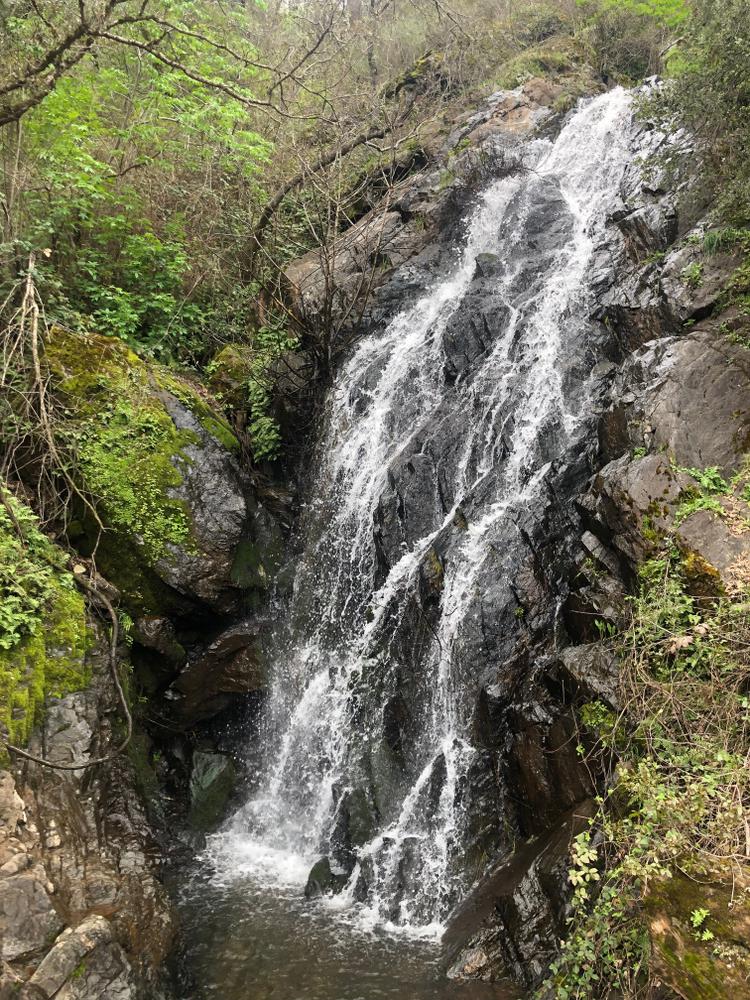
Travel less than an hour from Sacramento to Dutch Creek and Johntown Falls, where unforgettable adventure awaits. Located in Garden Valley, this moderately-rated trail takes you on a trip full of fun climbs and sprouting wildflowers.
Carefully make your way through the quaint rustic grounds to find a cascading showstopper marking the intersection of Dutch Creek and Johnston Falls. Sturdy hiking shoes are recommended here at one of the best hikes near Sacramento.
Location: Hidden Falls Regional Park, Newcastle
Level of Difficulty: Easy
Distance: 3.2 miles
Route: Loop
Dogs allowed: On leash
Whether you’re an expert hiker or a keen beginner looking for a day of exploration, chances are Hidden Falls Regional Park has something for you. Wander the twisting pathways on foot or ride your bicycle—bewildering back-country views serve as your curtain lifter along the way.
In the heart of the park, you’ll find a true Sacramento must-see—a breathtaking waterfall accessible from two observation points.
Location: Sutter’s Landing Regional Park, Sacramento
Level of Difficulty: Easy
Distance: 3.5 miles
Route: Out and back
Dogs allowed: On leash
This lightly trafficked trail is primarily used for walking and trail running. If you wish to escape the city bustle—even if just for a moment—the Levee Path is your ticket.
Shaded spots surround the river, making for an ideal resting place after a challenging run. Feel free to bring along your four-legged pal—this walking route welcomes all furry friends.
Location: Miller Park, Sacramento
Level of Difficulty: Easy
Distance: 8.6 miles
Route: Out and back
Dogs allowed: On Leash
The Sacramento Waterfront Trail shines as one of the area’s best hiking trails. The year-round trail network encircles the banks of the Sacramento River, offering Instagrammable views of the pedestrian bridges.
Enjoy the stunning mountainous landscape reflected in the blue waters. Don’t leave home without your furry companion.
Location: American River Parkway, Sacramento
Level of Difficulty: Easy
Distance: 4.7 miles
Route: Loop
Dogs allowed: Yes
When thinking of places to hike near San Francisco, the American River Parkway often comes to mind. Smooth trails pave a surface perfect for a leisurely stroll, surrounded by panoramic scenery from neighboring bridges.
If you’re in search of an adrenaline kick, there are several offshoot dirt trails offering steeper hikes for those looking for adventures.
After a lovely trekking adventure in Sacramento, check out the top sights and things to do.
Check out this beautiful Central Coast park with our guide to visiting Garrapata State Park.

Looking for great dance instruction in the Bay Area in a supportive and fun learning environment? Rae Studios shines with these qualities.

Get through the hot California days with these excellent ice cream shops in the Bay Area.

Explore California's top 5 film festivals, showcasing the best in independent, international, and LGBTQ+ cinema.

