


Fun and Free Things to Do in San Francisco
If you're looking for something fun to do, there are plenty of fun and free things to do in San Francisco, use our guide to help make plans.
Add these California volcanoes to your bucket list, and experience what it means to discover these menacing and majestic beauties.
Sunny, beachy, and dreamy California is also home to different types of volcanoes. The state has both extinct and active volcanoes; at least seven of them have magma bubbling underneath, indicating they could erupt again in the future. A combination of danger and glory, these volcanoes are related to the seismic activity of the state—something California has no shortage of.
But the hidden threats of the Golden State are also some of the most beautiful sights to see. Exciting, chilling, and magnificent, California’s volcanoes stand tall and beckon to curious travelers. Add these California volcanoes to your bucket list, and experience what it means to discover these menacing and majestic beauties.
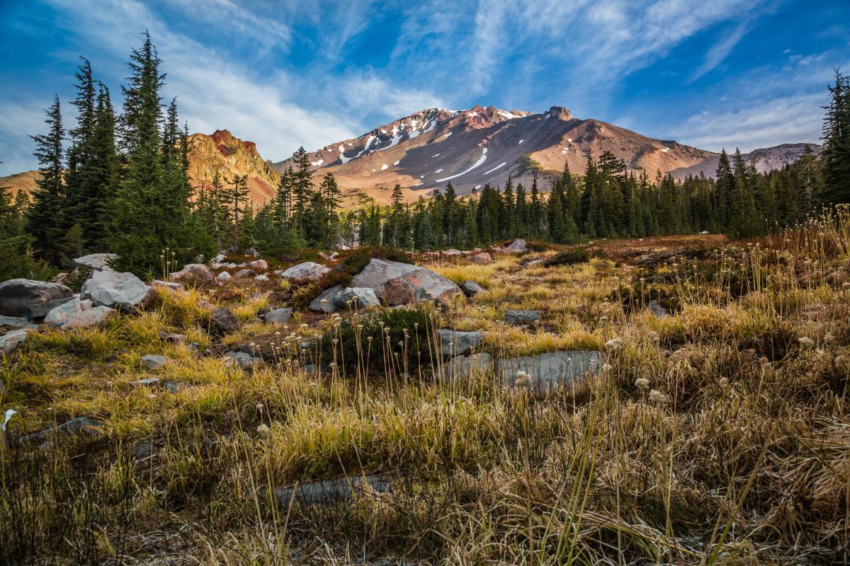
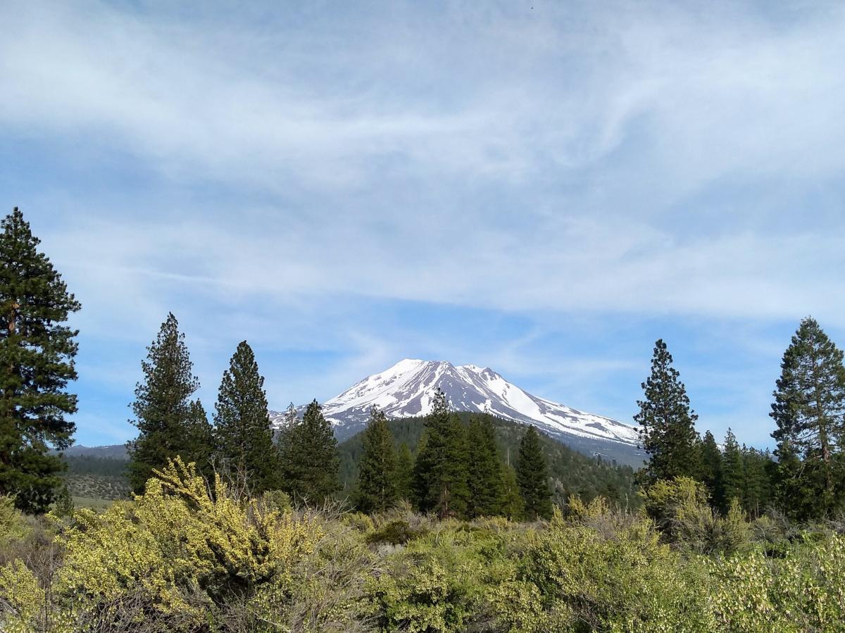
When you visit the Shasta Cascade, a grand, steep-sided stratovolcano comes into view. Mount Shasta, the most voluminous composite volcano found in the Cascade Range, is the fifth-highest peak in the Golden State. The volcano has a complex summit that consists of four overlapping volcanic cones, including the main summit and its prominent satellite cone. According to the record of eruptions, over the past 10,000 years, Mount Shasta has erupted once every 600 to 800 years (on average). The last time it erupted was in 1786.
When visiting the striking formation, stop by Castle Lake and Mount Shasta City Park to discover the wonders that surround the volcano. You can also ski here during the winter months. Attracting the attention of authors and poets, the breathtaking California volcano is also considered a powerful energy source for certain individuals.
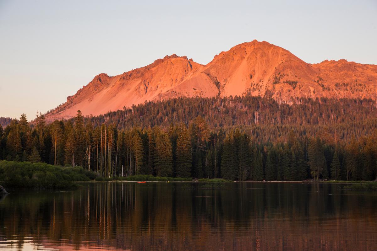
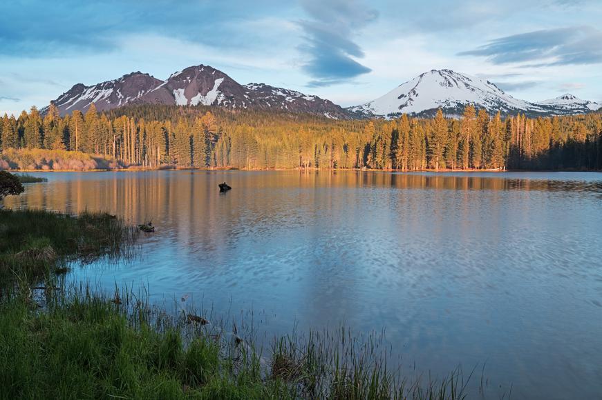
The main attraction at Lassen Volcanic National Park is, you guessed it, Lassen Peak. It was dormant for almost 27,000 years until the unexpected happened. Believed to be extinct, the southernmost active volcano in the Cascade Range erupted without a warning on May 30, 1914. Nearly one year later, on May 22 at 4:30 p.m., the Great Explosion of this California volcano took place, blasting volcanic ash, rock fragments, and pumice into the air. As a result, the larger and deeper of the two craters—which we now see near the summit of the volcano—were formed.
Eruptions continued until 1921 and consisted mostly of sporadic steam blasts. This fact hasn’t stopped people from visiting Lassen Peak. Given the adventure that awaits in this remote destination, Lassen Volcanic National Park is ideal for Aries but attracts all kinds of curious naturalists. Hundreds and thousands of visitors come to explore the nearby Manzanita Lake, hike the trails, camp for the night, and admire the bubbling pools of water.

Located northwest of Lassen Peak, Chaos Crags last erupted 1,100 years ago and is the youngest unit of the Eagle Peak sequence. Chaos Crags' most recent eruption resulted in the formation of six dacite domes; 70 years later, one of them violently collapsed. This triggered the growth of five domes, two of which had hot, dome-collapse avalanches.
During the early months of the year, a lake forms at the base of Chaos Crags and dries out by the end of summer. White firs, sugar cones, and Jeffrey pines are common in this California volcano area. Although accessible to all, Chaos Crags remains a hidden gem. Explore the area’s lakes and forests while hiking the Crags Lake Trail. Witness the beauty of the nearby volcanic phenomena when you reach the summit.

Located in Inyo County, Coso Volcanic Field is home to one of the largest producers of geothermal power in the U.S. Volcanism began in the Coso Range approximately six million years ago, fueling many hot springs, steam vents, and boiling mud pots nearby. Its most recent eruption occurred around 40,000 years ago; as a result, the Volcano Peak basaltic cinder cone and lava flow were formed. The maroon cinder cone, also known as "Red Hill," is visible to everyone driving along Highway 395.
Thanks to Coso Volcanic Field’s geothermal power, the California volcano supplies power to 270,000 homes and warms the hot spring complex of the field. The National Register of Historic Places has the Coso Hot Springs included in its list of significant landmarks, too.
Extending around 50 miles north-south and 30 miles east-west, Medicine Lake Volcano is an active threat. According to scientists, this California volcano is unique in the sense that it has many small magma chambers rather than just a large one. Over the past 4,000 years, there have been at least six eruptions. It last erupted around 1,000 years ago, and it's expected to erupt again in the future.
Due to the amount of lava it contains, Medicine Lake Volcano is the most voluminous volcano of the Cascades. Head here to perceive the beauty of Glass Mountain, the Medicine Lake caldera, and the Lava Beds National Monument, where you can discover lava-tube caves and well-preserved young volcanic features.
Interesting fact: The Modoc War, which was an armed conflict between the Native American Modoc people and the U.S. Army, took place at the volcano's north flank in the 19th century.
The poorly studied Brushy Butte is a California volcano located southeast of the Medicine Lake Highlands. Containing pyroclastic cones and lava flows, the volcano's features extend preferentially down the regional gradient to the south, stretching as far as the Fall River Valley. Hypothesized to have formed between 12,000 and 25,000 years ago, Brushy Butte’s last known eruption was during the Ice Age. Since not much is known about the volcano, you just have to go there and discover it yourself.
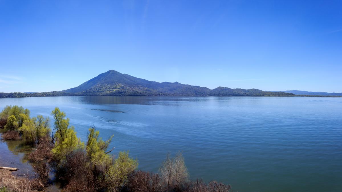
Standing tall at 4,305 feet, Mount Konocti is a mostly dacitic composite cone on the western shore of Clear Lake Volcanic Field. Classified by the U.S. Geological Survey as "high threat potential," the mighty mountain last erupted 11,000 years ago and contains the largest volume of dacite in the Clear Lake Volcanic Field.
Scientists believe Mount Konocti has natural caves and assume its central magma chamber is a vast, empty vertical cavern. However, it’s hard to prove its existence because of the unstable nature of the volcano’s cone. As the largest volcanic feature of Clear Lake, Mount Konocti formed its major edifice approximately 350,000 years ago.
Go on a hike near this fantastic volcano and learn about the geology to better appreciate the heart-stopping scenery. (Avid hikers, rejoice: The best Bay Area hikes and fantastic parks in the East Bay are just a couple of hours away from here.)
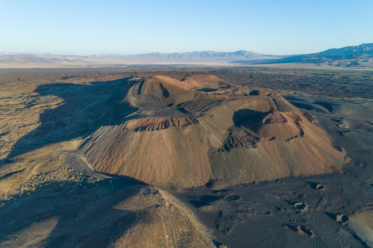
The main feature of the Lavic Lake volcanic field is Pisgah Crater, a prominent cinder cone surrounded by a basalt lava flow field. In the past, the volcano had an elevation of 2,638 feet, but due to ongoing mining operations, its height was reduced to 2,545 feet. It's unclear when Pisgah Crater last erupted, but it exploded at least three times, emptying its magma chamber.
The Pisgah Crater is most popular for its lava tubes. Take your friends caving here, and hike around this California volcano as the Mojave National Preserve peeks at you.
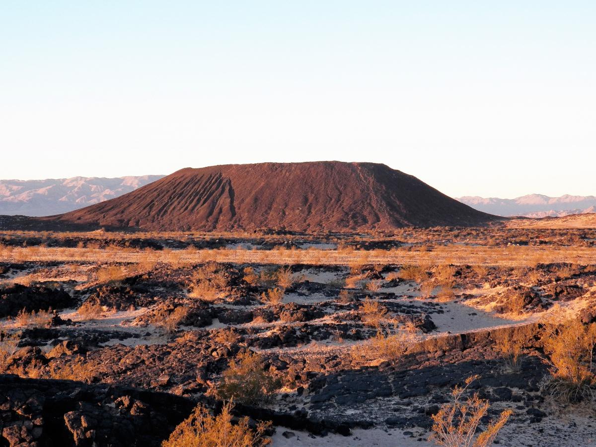
As you’re cruising down the historic Route 66, a show-stopping volcanic cinder cone comes into sight: Amboy Crater. The extinct volcano is just the place to go while on a desert hike. The almost-symmetric volcanic structure is located within Mojave Trails National Monument. The natural landmark contains mainly pahoehoe lava flows with only a few lava channels present, and its last eruption took place around 10,000 years ago.
Amboy Crater is composed of at least four nearby coaxial nested cones. Discover the geological miracle of the California volcano on a hike around the cone’s western half and into the caldera. The trail leads to where basaltic lava poured out over a vast area and created lava lakes, spatter cones, and collapsed lava tubes and sinks. Embrace the immensity of nature and soak in the desert landscapes.

If you're looking for something fun to do, there are plenty of fun and free things to do in San Francisco, use our guide to help make plans.

All waterfall hikes in L.A. have one thing in common—unbeatable views of terrific cascades. Here are the ones to try next.

From undulating mountains, to coastal expanses, to verdant forests, here are some of the top spots for backpacking in California.
Settled off the California coast, the Channel Islands offer endless adventures. Here are the best things to do and how to get there.

